“Archaeology is a way of acting and thinking—about what is left of the past, about the temporality of what remains, about material and temporal processes to which people and their goods are subject, about the processes of order and entropy, of making, consuming and discarding at the heart of human experience. These elements, and the practices that archaeologists follow to uncover them, is the essence of the archaeological imagination.”
In his book Shanks offers the following definition: “To recreate the world behind the ruins on the land, to reanimate the people behind the shard of antique pottery, a fragment of the past: this is the work of the archaeological imagination, a creative impulse and faculty at the heart of archaeology, but also embedded in many cultural dispositions, discourses and institutions commonly associated with modernity. The archaeological imagination is rooted in a sensibility, a pervasive set of attitudes toward traces and remains, towards memory, time and temporality, the fabric of history.” pp.25
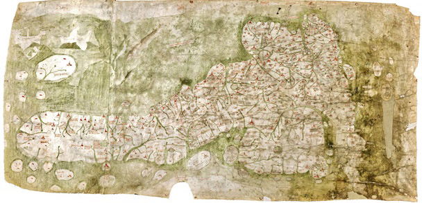
“The printer and publisher John Nichols described Richard Gough in a long tribute after his death as ‘the Father of British Topography’. More recently scholars have recognised him as the leading antiquary of his day. Gough was one of the first to recognise the importance of old maps in helping to understand the history of particular places and wrote a pioneering account of the development of British maps in the second edition of his British Topography (1780). This is the oldest map of Britain at the Bodleian Library, Oxfordshire (exact date unknown, approx. 14th Century). In addition, the topographical collection bequeathed by Gough to Oxford University in 1809 is one of the most important in the Bodleian Library, outstanding for the visual material received as well as the printed books and manuscripts. Among the maps is the earliest depiction of Britain in recognisable form (now known as the Gough Map) and large portions of the unique Sheldon tapestry map woven in the 1590s.
His Anecdotes of British Topography (1768) was the first comprehensive national bibliography of the subject and a remarkable achievement for one individual. It provided a gazetteer of sources relating to the local history and antiquities of each county, covering not just printed books and manuscripts but also maps and illustrations often with comments about dates, artists and when he acquired items. An enlarged second edition in two volumes was published in 1780 under the title of British Topography. Gough was one of the first to recognise the importance of old maps in helping to understand the history of particular places and wrote a pioneering account of the development of British maps in the second edition of his British Topography (1780).”
1] Richard Gough, British Topography. Or, an Historical Account of what has been done for Illustrating the Topographical Antiquities of Great Britain and Ireland, London, J. Nichols and T. Payne, 1780. The completed part of the 3rd edition was destroyed in 1808 by a fire in Nichol’s printing works. However the Bodleian has a copy of the 2nd edition with useful later additions by Gough (Gough Gen.Top. 363–5).
2] Peter Barber, ‘King George III’s topographical collection: a Georgian view of Britain and the world’, in Kim Sloan and Andrew Burnett (eds), Enlightenment: Discovering the World in the Eighteenth Century, London, British Museum, 2003, pp. 158–65.
3] The most useful guide to Gough’s topographical drawings is Maurice Barley, A Guide to British Topographical Collections, [London], Council for British Archaeology, 1974, pp. 95–8.