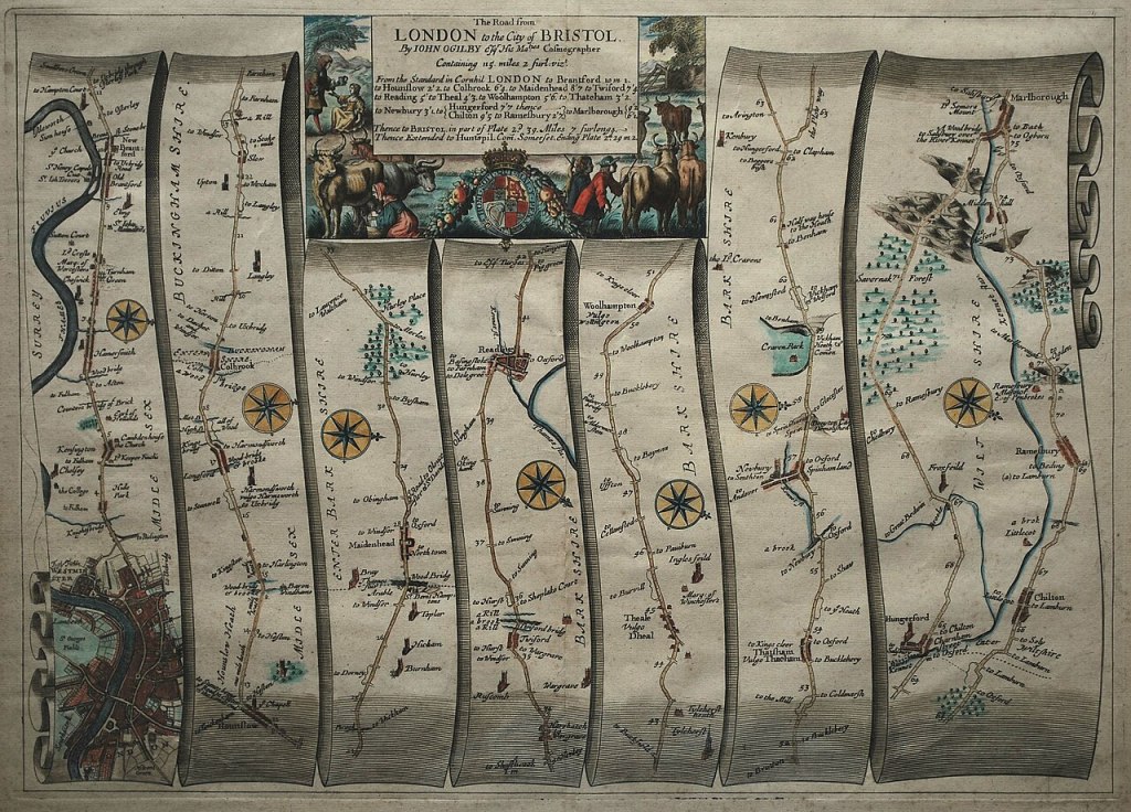
“John Ogilby, was born in Scotland in 1600, and held many different careers in his life; a dancing-master, theater owner, poet, translator, publisher and cartographer. He is most remembered for bringing English cartography into the scientific age with his 1675 road atlas of England and Wales titled, Britannia. To create the wonderfully detailed strip maps that displayed the topographical features and distances of the roads, Ogilby’s team of surveyors worked with the precise and easy-to-use perambulator or measuring wheel to record the distance of the roads in miles; implementing the standardized measurement of 1,760 yards per mile as defined by a 1592 Act of Parliament. They also used the surveyor’s compass or theodolite to better record the changes in the directions of the roads. Besides the use of scientific instruments, Britannia was also the first published work to use the scale of one inch equaling one mile, which became the prevailing scale for cartography. Through the use of detailed illustrations and precise technology, Ogilby’s Britannia became the first comprehensive and accurate road atlas for England and Wales, making it the prototype for almost all English road books published in the following century.”
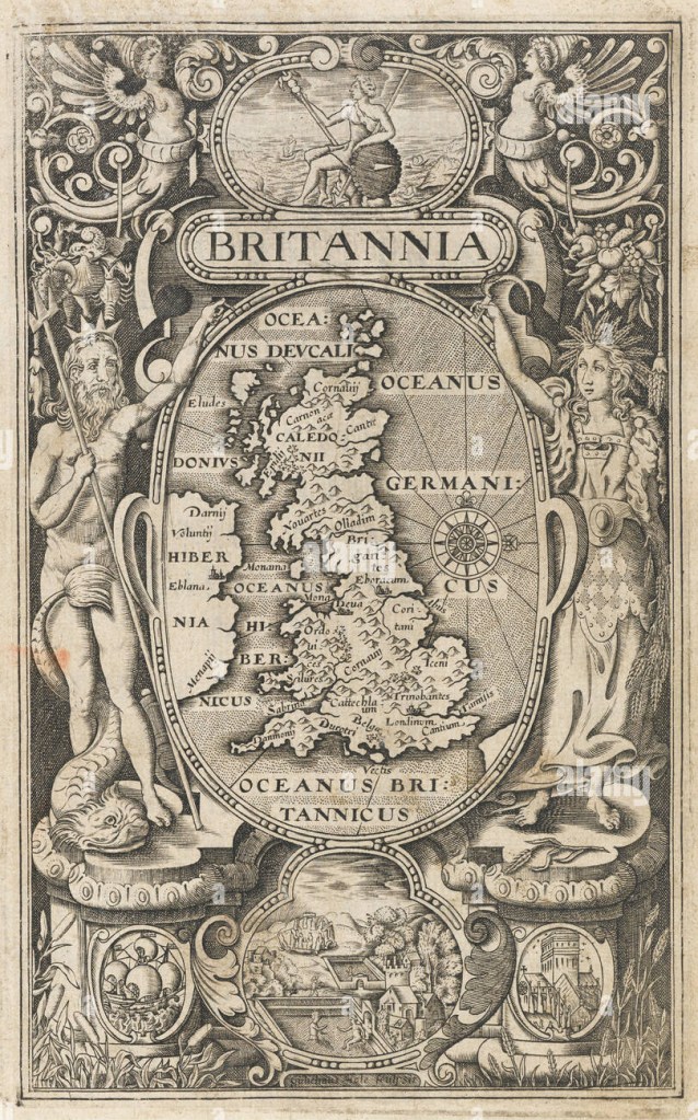
“A map of England, Wales, Scotland eastern Ireland, in an oval supported by Neptune and Ceres, with vignettes of Britannia sitting on a rock, a ship, St Paul’s Cathedral, and Stonehenge and the Roman Baths. On the map London and York are marked, but most of the other names are tribes. This frontispiece was one of three maps engraved by William Rogers (c.1545-c.1604) for the 1600 edition of William Camden’s ‘Britannia’, the fifth edition of the work, yet the first to contain maps. It was not until 1607 that a full suite of county maps was included, alongside a larger version of this map, engraved by William Hole.”
Chorography designates “a regional map in Renaissance geographic texts and the artistic description of regions” viewed and experienced from within linking “regional events at the time of occurrence in pictorial representations.” (Olwig 2001 and Curry 2005 cited in Päivi Kymäläinen and Ari A. Lehtinen 2010: 252). Chorography or place‐writing forms an aspect of the tri‐partite structure belonging to a classical Geographic distinction between Topography, Chorography and Geography, Päivi kymäläinen and Ari A. Lehtinen (2010). Chorography, defined by the polymath Ptolemy in the Geographike Hyphegesis (c.149AD) takes region as its lens. This field-based approach and detailed descriptor of place qualitatively maps characteristics of the locale by examining the constituent parts of that place “to describe the smallest details of places.” Morra J, Smith M (2006: 17-18). Cormack states “Chorography was the most wide ranging of the geographical subdisciplines, since it included an interest in genealogy, chronology, and antiquities, as well as local history and topography…unit[ing] an anecdotal interest in local families and […] genealogical and chronological research.” (Cormack 1991 cited in Rohl 2011: 22).
Chorography was re-discovered in Renaissance Geography and British Antiquarianism 16th -17th centuries. Historically William Camden’s Brittania (1586) or a Chorographicall Description of the most flourishing Kingdomes, England, Scotland, and Ireland is an encyclopaedic approach to a geographic, historical topographical survey of the British Isles which has been identified as a classic exemplar of the renaissance of a chorographic work “connecting past and present through the medium of space, land, region or country.” (Rohl 2011: 22). Camden’s place in this changing historiographical framework of the English Renaissance is critical to elevating the field of historical studies in tandem with scientific documentation as a new and original contribution to knowledge and the discovery of ‘England’ and a sense of ‘Englishness’ (Richardson 2204: 112).
With its overriding pre-occupation with place Camden’s Brittania (1586), arranged chronologically, is a county-by-county survey of England & Wales which travels from the South to the North and represents a new ‘topographical-historical method’ (Mendyk 1986 cited in Rohl 2011: 22). The science of map making was still in it’s infancy but Camden was linked to its development and utilised it when it became available (Richardson 2004:117). Cartographic representations however “aim at synchronic representation”, chorographic descriptions of the countryside, by contrast, opt instead for the diachronic.” Reconstructing a topographically organised historical account in a specific area. Hence in Marchitello’s formulation “Chorography is the typically narrative and only occasionally graphic practice of delineating topography not exclusively as it exists in the present moment, but as it has existed historically. This means not only describing surface features of the land (rivers, forests, etc.), but also the “place” a given locale has held in history, including the languages spoken there, the customs of it’s people, material artefacts the land may hold, and so forth.” Marchitello in (Swann 2001, p.101). British Antiquarianism therefore retrieved chorography and recreated it in an expanded field, re-interpreting its legacy, ensuring its survival, restoration and continuing communication. Susan Stewart discusses the antiquarian as being “moved by a nostalgia of origin and presence” whose “function is to validate the culture of ground.” (1984:153)


.jpg)