The Gough Map

The Gough Map

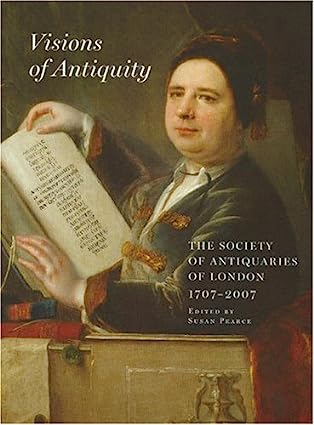
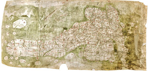
“The printer and publisher John Nichols described Richard Gough in a long tribute after his death as ‘the Father of British Topography’. More recently scholars have recognised him as the leading antiquary of his day. Gough was one of the first to recognise the importance of old maps in helping to understand the history of particular places and wrote a pioneering account of the development of British maps in the second edition of his British Topography (1780). This is the oldest map of Britain at the Bodleian Library, Oxfordshire (exact date unknown, approx. 14th Century). In addition, the topographical collection bequeathed by Gough to Oxford University in 1809 is one of the most important in the Bodleian Library, outstanding for the visual material received as well as the printed books and manuscripts. Among the maps is the earliest depiction of Britain in recognisable form (now known as the Gough Map) and large portions of the unique Sheldon tapestry map woven in the 1590s.

His Anecdotes of British Topography (1768) was the first comprehensive national bibliography of the subject and a remarkable achievement for one individual. It provided a gazetteer of sources relating to the local history and antiquities of each county, covering not just printed books and manuscripts but also maps and illustrations often with comments about dates, artists and when he acquired items. An enlarged second edition in two volumes was published in 1780 under the title of British Topography. Gough was one of the first to recognise the importance of old maps in helping to understand the history of particular places and wrote a pioneering account of the development of British maps in the second edition of his British Topography (1780).”

Text and image reproduced from https://www.bl.uk/picturing-places/articles/richard-gough-the-father-of-british-topography (accessed 21/07/23)

References for further research:

1] Richard Gough, British Topography. Or, an Historical Account of what has been done for Illustrating the Topographical Antiquities of Great Britain and Ireland, London, J. Nichols and T. Payne, 1780. The completed part of the 3rd edition was destroyed in 1808 by a fire in Nichol’s printing works. However the Bodleian has a copy of the 2nd edition with useful later additions by Gough (Gough Gen.Top. 363–5).

2] Peter Barber, ‘King George III’s topographical collection: a Georgian view of Britain and the world’, in Kim Sloan and Andrew Burnett (eds), Enlightenment: Discovering the World in the Eighteenth Century, London, British Museum, 2003, pp. 158–65.

 3] The most useful guide to Gough’s topographical drawings is Maurice Barley, A Guide to British Topographical Collections, [London], Council for British Archaeology, 1974, pp. 95–8.

Poly-Olbion

William Hole’s frontispiece (from the Folger Shakespeare Library [http://luna.folger.edu/luna/servlet/s/7ihql3])

“Poly-Olbion is an expansive poetic journey through the landscape, history, traditions and customs of early modern England and Wales. Originally published in two parts (1612, 1622), it is also a richly collaborative work: Michael Drayton’s 15,000-line poem, which navigates the nation county by county, is embellished by William Hole’s thirty exquisite engraved county maps, and accompanied for its first eighteen ‘songs’ by the young John Selden’s remarkable prose ‘Illustrations’. Drayton was a close associate of Shakespeare and Ben Jonson, and his Poly-Olbion crystallizes early modern ideas of nationalism, history and memory.”

Image and text reproduced from https://poly-olbion.exeter.ac.uk/ (accessed 09/07/23)

Visions of Antiquity

So I’m having to do some fairly niche reading for my PhD, which starts in October, since I am investigating a concept from the 16th-17th centuries although it’s provenance is much older than that and begins with Ptolemy’s Geographia (149AD). I am tracing it’s roots and development through British History and Antiquarianism (the historical precursor to Archaeology) which flourished in the 17th century and was part of an epic effort to map Britain, one famous example being William Camden’s Brittania (1586). With its overriding pre-occupation with place Camden’s Brittania, arranged chronologically, is a county-by-county survey of England & Wales which travels from the South to the North and represents a new ‘topographical-historical method’ (Mendyk 1986 cited in Rohl 2011: 22).

The book articulates the image of the antiquary in 17thC England, it’s relation to the graphic arts, art and antiquity in the long 19th Century, the interpetation of ancient objects, prehistory in the 19thC, nineteenth-century antiquarian culture and the project of archaeology, antiquaries and conservation of the landscape, grand excavation projects of the twentieth century and antiquaries and the professionalization of archaeology.

I am hard at work on my Bibliography and see some exciting trips to the Bodleian library, Oxford in the future.

Key words: antiquarian, antiquities, archaeology, barrow, conservation, culture, England, excavation, landscape, place, history

Currently Reading

Making Place, Making Self explores new understandings of place and place-making in late modernity, covering key themes of place and space, tourism and mobility, sexual difference and subjectivity. Using a series of individual life stories, it develops a fascinating polyvocal account of leisure and life journeys. These stories focus on journeys made to the North Cape in Norway, the most northern point of mainland Europe, which is both a tourist destination and an evocation of a reliable and secure point of reference, an idea that gives meaning to an individual’s life. The theoretical core of the book draws on an inter-weaving of post-Lacanian versions of feminist psycho-analytical thinking with phenomenological and existential thinking, where place-making is linked with self-making and homecoming. By combining such ground-breaking theory with her innovative use of case studies, Inger Birkeland here provides a major contribution to the fields of cultural geography, tourism and feminist studies.

Text and image reproduced from https://www.amazon.co.uk/Making-Place-Self-Subjectivity-Difference/dp/1138255238 (accessed 04/06/23)