John Ogilby Brittania 1675

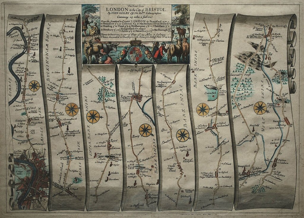
“John Ogilby, was born in Scotland in 1600, and held many different careers in his life; a dancing-master, theater owner, poet, translator, publisher and cartographer. He is most remembered for bringing English cartography into the scientific age with his 1675 road atlas of England and Wales titled, Britannia. To create the wonderfully detailed strip maps that displayed the topographical features and distances of the roads, Ogilby’s team of surveyors worked with the precise and easy-to-use perambulator or measuring wheel to record the distance of the roads in miles; implementing the standardized measurement of 1,760 yards per mile as defined by a 1592 Act of Parliament. They also used the surveyor’s compass or theodolite to better record the changes in the directions of the roads. Besides the use of scientific instruments, Britannia was also the first published work to use the scale of one inch equaling one mile, which became the prevailing scale for cartography. Through the use of detailed illustrations and precise technology, Ogilby’s Britannia became the first comprehensive and accurate road atlas for England and Wales, making it the prototype for almost all English road books published in the following century.”

1st image and text reproduced from https://blogs.lib.ku.edu/spencer/ogilbys-britannia-bringing-english-cartography-into-the-scientific-age/ (accessed 10/03/24). Map https://commons.wikimedia.org/wiki/Category:John_Ogilby_%281675%29_Britannia_Atlas#/media/File:John_Ogilby_-_The_Road_from_London_to_the_City_of_Bristol_(1675).jpg (accessed 10/03/24)

Remains of Elmet: A Pennine Sequence (1979)

Fay Godwin
Top Withens by Ted Hughes

“Ted Hughes (1930-1998) was born at 1 Aspinall Street, Mytholmroyd, in the West Riding of Yorkshire on the 17th August 1930. Ted was a pupil at the Burnley Road School until he was seven, when his family moved to Mexborough, in South Yorkshire. As a child he spent many hours exploring the countryside around Mytholmroyd, often in the company of his older brother, Gerald, and these experiences and the influences of the landscape were to inform much of his later poetry.

In ‘The Rock’, an autobiographical piece about his early childhood, Hughes writes about Scout Rock, whose cliff face provided ‘both the curtain and back-drop to existence‘. The area continued to be a powerful source of inspiration in his poetry long after he had left Yorkshire. Hughes described the experience of looking out of the skylight window of his bedroom on 1 Aspinall Street onto the Zion Chapel. The Chapel is long gone, but Zion Terrace remains, its name a reminder of more God-fearing times.

In his classic and richly personal collection Remains of Elmet: A Pennine Sequence (1979), with photographs by Fay Godwin, Hughes suggests that the Calder Valley was originally the kingdom of Elmet, the last Celtic land to fall to the Anglo-Saxons. A second, revised edition was published as Elmet in 1994. 

Many of Hughes’s other poems also relate to the Calder Valley. ‘Six Young Men’, for example, was written at Hughes’s parents’ house at Heptonstall Slack in 1956. The poem describes a photograph belonging to Hughes’s father of six of his friends on an outing to Lumb Falls, taken just before the First World War.”

Text reproduced from https://www.theelmettrust.org/elmet-trust-ted-hughes/ (accessed 25/01/23). Images reproduced from Pinterest.

Currently Reading

Deep maps are finely detailed, multimedia depictions of a place and the people, buildings, objects, flora, and fauna that exist within it and which are inseparable from the activities of everyday life. These depictions may encompass the beliefs, desires, hopes, and fears of residents and help show what ties one place to another. A deep map is a way to engage evidence within its spatio-temporal context and to provide a platform for a spatially-embedded argument. The essays in this book investigate deep mapping and the spatial narratives that stem from it. The authors come from a variety of disciplines: history, religious studies, geography and geographic information science, and computer science. Each applies the concepts of space, time, and place to problems central to an understanding of society and culture, employing deep maps to reveal the confluence of actions and evidence and to trace paths of intellectual exploration by making use of a new creative space that is visual, structurally open, multi-media, and multi-layered.

Carte De Tendre

‘The Carte de Tendre or the ‘Map of Tender Love’ appeared in the 17th Century novel Clélie by
Madeleine de Scudéry. It is an allegorical love map, ‘a set of instructions in love. The lover who
reads such a map is, at it were, travelling on the body of his or her love.’[1] ‘The country is
bisected by the Inclination a river that runs south to north, joined by two smaller rivers, Respect
and Gratitude before plunging into La mer dangereuse, the Dangerous Sea (unbridled emotions)
which is separated from a reef-ridden narrows, the Terres inconnues, Unknown Land.’[2] The
eroticised body is fleshed out so to speak in the form of a landscape, a libidinal topography of
het-erogenous zones. In The Book of Disquiet Pessoa mentions the Tender Map in relation to a
‘geography of our consciousness’ suggesting reality is a complex equivalent to ‘complicated
coastlines, lakes and rugged mountains.’ [3]

1] Gandelman, Claude, Reading Pictures Viewing Texts, Indiana University Press: Bloomington and Indianapolis, USA 1991 p.81/89

2] Image reproduced and text from https://bigthink.com/strange-maps/245-loves-topography-la-carte-de-tendre/ (accessed 25/07/12)

3] Pessoa Fernando, The Book of Disquiet, Ed. Lancastre Maria José de, Trans. Costa Margaret Jull, Serpent’s Tail: London 1991, p.147

Robert Smithson – Strata

Robert Smithson – Strata 1970

“Robert Smithson’s photo-essay “Strata” was published in 1970, the same year Anderson’s recycling symbol was released. 1970 also witnessed the inaugural Earth Day, which consecrated an ecological movement that had been building over the decade. Smithson’s own Earth Art during the 60s and into the 70s was similarly concerned with pollution, land reclamation and ecology, though his interests led him always to contemplate the Earth’s matter on an extremely wide time-scale.

“A book is a paper strata,” Smithson says, stringing snippet-like descriptions of distant times together with mentions of x-rays, stereoscopes and dioramas in museum displays, emphasizing the latter’s near-obsolescence so as to project the reader into the museum’s (and the text’s) entropic future. The canny paratactic construction of “Strata,” telegraphic in style and lacking conjunctions and transitions, links past, present and future through verbal abutments and layerings that connect as much as they disjoin. The point bears repeating, as Smithson’s ecological consciousness emphasizes the mind’s distance from the matter it contemplates, a distance given dynamic form in his dialectic of site and non-site, a conjoining disjunction that both bridges the gap between museum and natural site yet defies synthesis in opening the dialectic onto entropic processes in both space and time.

Sea butterflies fall into a nameless ocean. Plaster restorations collecting dust in the Museum of Natural History. The tracks of trilobites harden into fossils. Accumulations of waste on the sea bottoms. Jelly-fish baking under the sun. Digestive systems shown in diagrams. … A tendency to amorphousness….”

Image and text reproduced from https://johnculbert.wordpress.com/tag/strata-a-photogeographic-fiction/ (accessed 11/11/23)