“Bringing together contributions by artists, writers and theorists, ‘Fieldwork for Future Ecologies’ addresses the role that art practice and art-based research plays in expanding notions of fieldwork. At once a handbook for research and practice and a philosophical speculation, this book offers the unique opportunity to explore ways of working within vastly diverse climates and terrains using image, sound, movement and other sensing technologies. It also offers more creative and speculative interventions into the idea and location of the ‘field’ itself.
Focusing on a range of projects from across different geographic locations and situations, the book highlights the crucial contribution that art can make to environmental and climate studies offering a valuable intervention into current discussions of artistic practice and research. ‘Fieldwork for Future Ecologies’ presents a series of propositions and speculations … radical practices for radical times.
Contributing authors: Angus Carlyle, Alliance of the Southern Triangle/AST (D Bauer, F Grodin, P M Hernandez, E Kedan), Bianca Hester, Bridget Crone, David Burns, Henriette Gunkel and Eline McGeorge, Imani Jacqueline Brown, Julie Gough, Kate Pickering, Kreider + O’Leary, Kristen Sharp, Melody Jue, Nicholas Mangan, Philip Samartzis, Polly Stanton, Ruth Maclennan, Sam Nightingale, Saskia Beudel, Simon O’Sullivan, Susan Schuppli, Therese Keogh.“
The Chorography of Place: Mapping new ecologies of landscape, memory, history and visual culture.
This PhD by practice aims to explore chorography’s relevance as an organising principle in contemporary artistic practice and critically address the historic yet neglected role of chorography in the documentation of place. Chorography, or place writing, is the artistic representation of a regional map which originated in Classical Geography (c.149AD). This field-based approach and detailed descriptor of place takes region as it’s lens and qualitatively maps characteristics of the locale by examining the constituent parts of that place. If a sensory physical mapping of place occurs prior to representation where is the body in the process of chorography?
There is a need to distinguish this act from its documentation and re-presentation to provide new theories, forms and applications by addressing the political implications of the embodied in the act of representation. To provide a contemporaneous account the performative relations between the body, mapping and place; the mobile, embodied and situated are therefore central to a contemporary interpretation of chorography.
To enact these relations sites chosen for their historic, symbolic or mythological significance include Brontë Country which straddles West Yorkshire and the East Lancashire Pennines, the Devil’s Bridge in Wales and St. Michael’s Mount, Cornwall. Applying chorographic methods in artistic practice I aim to realise a historically grounded exploration of place by performing and documenting embodied, visual, textual and symbolic mappings. These mappings will form the basis of artworks, critical and performance writing, book works, performance and installation which will translate chorographic methods and the physical act of mapping into artistic practice. Combining historic method with contemporaneous form will enable a renewed understanding of the chorography of place not just artistically but physically, contextually and historically.
“The faery solitude of the place…his castle that lay on the very bosom of the sea…. at home neither on land or water, a mysterious amphibious place, contravening the materiality of both earth and waves…That lovely, sad, sea-siren of a place!.” The Bloody Chamber, p.8-9
This very brief analysis explores how we can approach gendered relations from the perspective of location to reveal the symbolic and metaphorical significance of Mont. Saint- Michel as it is employed in Angela Carter’s The Bloody Chamber. This analysis was given recently in a very short presentation. Examining Mont. Saint- Michel I explore its potential to represent feminine and masculine principles, nature and culture and how it is central to relations between the bride, her mother and the Marquis. Working through visual and sonic imagery highlights the relations between female anatomy, biology and the cyclical feminine flow ontology of the ‘sea-girt’. My interest lay specifically in the concept of the sea-girt, as a border or boundary surrounded or enclosed by the sea and how we might consider this in relation to the porous and the feminine. Continue reading →
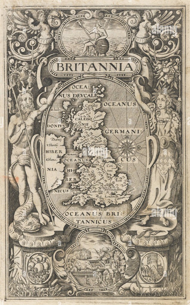
“A map of England, Wales, Scotland eastern Ireland, in an oval supported by Neptune and Ceres, with vignettes of Britannia sitting on a rock, a ship, St Paul’s Cathedral, and Stonehenge and the Roman Baths. On the map London and York are marked, but most of the other names are tribes. This frontispiece was one of three maps engraved by William Rogers (c.1545-c.1604) for the 1600 edition of William Camden’s ‘Britannia’, the fifth edition of the work, yet the first to contain maps. It was not until 1607 that a full suite of county maps was included, alongside a larger version of this map, engraved by William Hole.”
Chorography designates “a regional map in Renaissance geographic texts and the artistic description of regions” viewed and experienced from within linking “regional events at the time of occurrence in pictorial representations.” (Olwig 2001 and Curry 2005 cited in Päivi Kymäläinen and Ari A. Lehtinen 2010: 252). Chorography or place‐writing forms an aspect of the tri‐partite structure belonging to a classical Geographic distinction between Topography, Chorography and Geography, Päivi kymäläinen and Ari A. Lehtinen (2010). Chorography, defined by the polymath Ptolemy in the Geographike Hyphegesis (c.149AD) takes region as its lens. This field-based approach and detailed descriptor of place qualitatively maps characteristics of the locale by examining the constituent parts of that place “to describe the smallest details of places.” Morra J, Smith M (2006: 17-18). Cormack states “Chorography was the most wide ranging of the geographical subdisciplines, since it included an interest in genealogy, chronology, and antiquities, as well as local history and topography…unit[ing] an anecdotal interest in local families and […] genealogical and chronological research.” (Cormack 1991 cited in Rohl 2011: 22).
Chorography was re-discovered in Renaissance Geography and British Antiquarianism 16th -17th centuries. Historically William Camden’s Brittania (1586) or a Chorographicall Description of the most flourishing Kingdomes, England, Scotland, and Ireland is an encyclopaedic approach to a geographic, historical topographical survey of the British Isles which has been identified as a classic exemplar of the renaissance of a chorographic work “connecting past and present through the medium of space, land, region or country.” (Rohl 2011: 22). Camden’s place in this changing historiographical framework of the English Renaissance is critical to elevating the field of historical studies in tandem with scientific documentation as a new and original contribution to knowledge and the discovery of ‘England’ and a sense of ‘Englishness’ (Richardson 2204: 112).
With its overriding pre-occupation with place Camden’s Brittania (1586), arranged chronologically, is a county-by-county survey of England & Wales which travels from the South to the North and represents a new ‘topographical-historical method’ (Mendyk 1986 cited in Rohl 2011: 22). The science of map making was still in it’s infancy but Camden was linked to its development and utilised it when it became available (Richardson 2004:117). Cartographic representations however “aim at synchronic representation”, chorographic descriptions of the countryside, by contrast, opt instead for the diachronic.” Reconstructing a topographically organised historical account in a specific area. Hence in Marchitello’s formulation “Chorography is the typically narrative and only occasionally graphic practice of delineating topography not exclusively as it exists in the present moment, but as it has existed historically. This means not only describing surface features of the land (rivers, forests, etc.), but also the “place” a given locale has held in history, including the languages spoken there, the customs of it’s people, material artefacts the land may hold, and so forth.” Marchitello in (Swann 2001, p.101). British Antiquarianism therefore retrieved chorography and recreated it in an expanded field, re-interpreting its legacy, ensuring its survival, restoration and continuing communication. Susan Stewart discusses the antiquarian as being “moved by a nostalgia of origin and presence” whose “function is to validate the culture of ground.” (1984:153)
Introduction: Analysis of the following articles have revealed problems in defining the field of chorography as well as methods, theories and insights which warrant further examination. These summaries identify, illuminate and reflect on these issues and their implications in theory and practice.
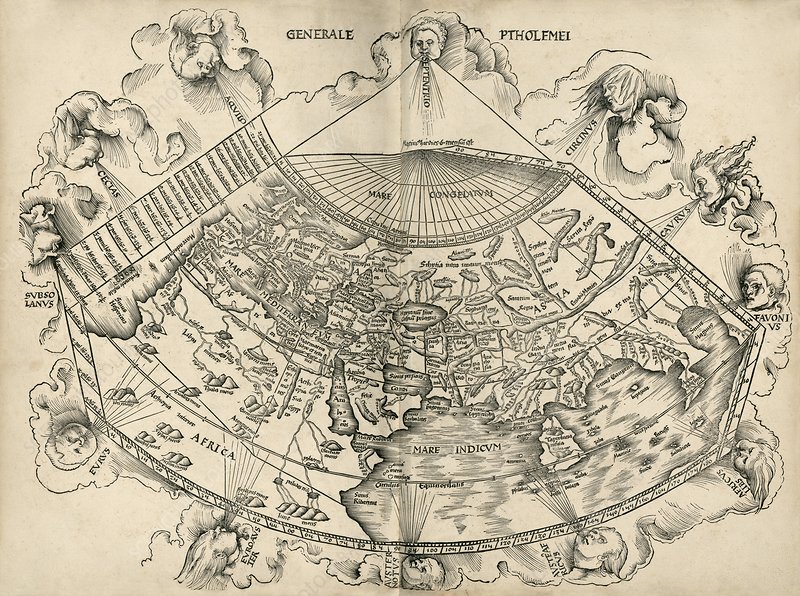
Ptolemy’s world map. This map of the world is from an edition of Ptolemy’s ‘Geographia’, published in 1513 by German cartographer Martin Waldseemuller (c.1470-1520)
Curry’s paper is concerned with the conflation of place and space in contemporary discourse which commonly obfuscate and erase their differences. His primary aim is to elaborate upon the terms chorography, topography and geography and delineate their differences by examining their ‘technologies and practices’. He suggests chorography is limited to the geographer’s knowledge, clearly in the context of this research this is not the case and in his own words ‘it is alive and well.’ Curry argues these geographic ways of knowing each have their own objects of study; region, place and the earth’s surface. He is critical of both their neglect in discussions of place or analyses which focus on scale in relation to these concepts as opposed to form and function. Curry employs a complex analogy of the invention of the US ZIP code to illuminate his argument.
Curry compares and contrasts these terms by tracing and re-interpreting their origins to distinguish them from contemporary understandings. He locates chorography and topography within foundational concepts of place and memory. Chorography was a qualitative way of interpreting the world, both celestial and terrestrial, and this knowledge was located in ‘signs or symbols’ which aimed to perceive relations ‘between events, places and the times of their occurrence’. He relocates topography’s association with mapping by placing it in the oral tradition and the ‘art of memory’. In this context places are created, narrated, performed and re-formed through symbolic associations. Place and experience are coextensive with each other and this element of the mnemonic has already been established independently in prior research.
For Curry the importance of this argument is not simply a matter of different scales of apprehension, but more significantly is intrinsically linked to repositories of knowledge, dissemination and retrieval. He argues space was ‘invented’ against the backdrop of place, due to emergent technologies necessitated by an increase in information, leading to an erasure of the chorographic and topographic by the geographic. Chorography and topography represent human patterns of knowing and belonging in contrast to the panoptic vision of geography. The implications of this observation equate to an erasure of memory practices and a movement from an embodied and emplaced performance of knowledge to its commodification. Places are increasingly mediated by technology and this also applies to the digital records of archaeological fieldwork. For instance when I was introduced to archaeological fieldwork at Erddig, Wales the corresponding planar database managed by the Historic Buildings, Sites and Monuments Record comprises 24 topographic views of each location in the field; a complex palimpsest inconceivable in a single view. This centralization of information which allows for the preservation of heritage data becomes an abstracted space of typology and categorization devoid of the people that inhabited them or the places that created them.
Curry’s analogy of the standardisation of the ZIP code can, in the context of this paper, be equated with geography reaching its empirical, scientific, mathematical and spatial exactitude in the art of cartography. This organisation of geographical knowledge, in the case of the ZIP code, privileges spatial points and co-ordinates whereby the particularities of place, regions, difference, the local and thus topography and chorography are subsumed and erased by spatial systematisation, the realm of demographics and the global organisation of information.